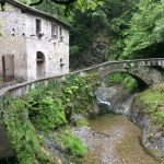
From piazza Belvedere in Vezio (elevation 250m) the orange signs should be followed down towards Val Grande (opposite to the houses of Perledo); crossing the Esino stream over a stone bridge and passing alongside ‘Mulino del Crott’ (elevation 282m). A ‘crotto’ is a meeting place where you can lose your sense of time and enjoy plenty of wine. From the bridge, you can catch a glimpse of the mouth of the stream where the skeleton of a prehistoric reptile was discovered many years ago. Now it is preserved in Milan’s Museum of Natural History and the bizarre name of Lariosaurus was given to it.
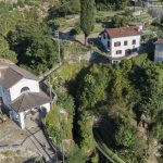
You climb up the road, turn right and then immediately left to start up the steps which in a short while lead to the gated chapel of Madonna di Campallo. Then you continue onwards, between terraced meadows with views over the hills of Vezio, initially below the houses and then enter Regoledo (elevation 347m), a hamlet of Perledo, until you reach the small square with the church of San Giovanni Battista.
The route then continues between the olive trees in the direction of the centre of Perledo (elevation 403m). When you arrive at a chapel alongside the road (Via per Esino), bear right along the path leading to the sports ground and the public gardens.
Now you climb up Via Faggi that lead to the centre of the village which is decorated by an 18th-century well. Then you turn left to the church square of San Martino, where you can enjoy one of the most well-known views over the lake. After having passed this square, you walk down for a short while until you reach the town hall. Next, you bear right towards the main road which you will run into after a sharp bend near Bar Milano.
Continue right on Via per Esino for a short while, then turn to the left onto Via degli Eroi, towards the graveyard.
After the square in front of the cemetery (elevation 401m), the road narrows to a lane in the hamlet of Tondello and continues downwards onto another road (Via Cava Alta) to Regoledo, which the route follows to the right for quite a while. The slope above us, covered in ancient chestnut trees, carries the disconcerting name of ‘Bosco delle Streghe’ or ‘Witches Wood’.
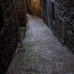
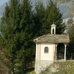
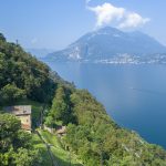
When we reach the top of the climb at the Maglia chapel (elevation 401m), dating back to the 18th century, a different view of the lake appears in front of us, revealing a large part of its upper section up to Dervio. Beside the chapel, the route continues along a mule-track whose steps have retained their beautiful cobbled structure. In a few minutes, you will arrive at the church of Gittana, whose high bell tower is already visible.
The beautiful cobbled path drops down beside the Maglia chapel, soon arriving at the front porch of the church of Gittana (elevation 359m). Alongside the church there is a small shrine dedicated to the Madonna delle Grazie, which includes a crucifix and a star belonging to the original Roman building.
Passing beside the church you will reach a road, which you have to cross and then continue along the cobbled pathway, which soon reaches the cemetery of Gittana.
You enter the woods, navigating your way above the houses of Gittana and then walking down to the watershed of Valla Masna (a path on the left climbs from Gittana). Continuing along the hillside path, you will walk up to the houses of Cestaglia (elevation 379m) and then re-enter the woods.
After a while, you will come across a deep trench which cuts across the mountainside. This is the abandoned site of the funicular railway which connected the railway and the small port below to Regoledo from 1903 until the mid-1950s. In 1858, a hydrotherapy spa was opened here, welcoming such famous guests as Cesare Cantù, Antonio Stoppani, Massimo d’Azeglio and Arturo Toscani. Furthermore, according to the Balbiani guide (“Como, its lake and valleys”, 1877), “nobody, whether healthy or sick, will regret visiting Regoledo in search of enjoyment, relax and well-being”. The building can still be seen, perched high above overlooking a clearing. After a few more steps, you will pass by a chapel with the remains of a 15th-century crucifix. A few other surprises also lie here: three boundary stones on the left side of the pathway dating back to 1732, demarcating Varenna, Bellano, Perledo and one further on, on the right. As frequently happens, the path marks the boundary between different municipalities. Where the wood clears into meadows, there is a pretty cluster of rural buildings, including the so-called ‘Fabbrica’ or ‘Factory’ (elevation 341m), recognisable from its ornate gateway and attractive balcony. It was used for a range of purposes, including a restaurant, a silkworm farm, a shop and a wine cellar.
Once you cross the bridge, nicely rebuilt in wood, over the small valley of Biosio, you walk down to the Pioverna delta where Bellano is located.
The isolated chapel of Madonna Addolorata (elevation 301m) comes just before the start of the SP62 which continues along the right-hand side for a few dozen meters before diverting towards the bridge of San Rocco, the adjacent church and the ravine below. From here, you can walk down to Bellano or, on the right, beside the church, continue along the Sentiero del Viandante.
