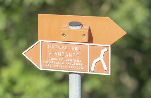
History of Sentiero del Viandante
Sentiero del Viandante represents one of the treasures of Como Lake and the lower Valtellina.
A jewel to be care for, to preserve and to enhance. The program agreement signed by all the municipalities, the three “Comunità Montana”, and the two Provinces over which the trail passes is a clear attestation of the administrators’ intentions and will to protect and make known this trail.
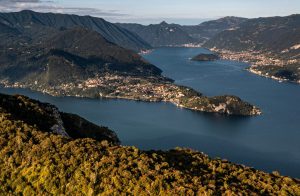
Panoramic view of the lake
Como Lake had been a natural corridor facilitating trade flows between the north and the south via the Alps since Roman times and perhaps even before. The passes over the Rhaetian Alps (Spluga, elevation 2116 m; Maloja, elevation 1815m; Settimo elevation 2313m) are relatively close, 50 km on average, to what used to be called the lake’s upper “port” – Riva di Chiavenna – the northernmost point from where boats loaded with goods could be launched. Before the advance of the Adda delta in Bassa Valtellina (15th century) and the subsequent reclamation of the Plain of Chiavenna (19th – 20th century), the Como Lake extended further north than it does today. The municipality of Samolaco, in Valchiavenna, is a reminder of that: its name comes from latin summus lacus which means “top of the lake”. The small lake of Novate Mezzola is a remnant of Como Lake separated from the outflow of the Adda river. The Lario triangle is the best place to admire the Alpine divide, which forks into the steep valleys of Reno towards Coira and Constance Lake.
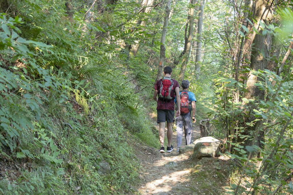
Sentiero Viandante Nei pressi di Biosio
Despite being far from the traffic flow coming from Milan and for a period belonging to the Venetian Republic, the Bergamasque Prealps represented an obstacle to communication and always needed negotiating, either by taking San Marco pass or the Tartano and Dordona passes, which are some of the most well-known, in order to reach the Valtellina and the slopes of the Rhaetian Alps. Even when the Gotthard pass was crossed, which became hugely important from the 13th century with the construction of the route along the dangerous Schollenen gorge, it was possible to reach Milan only by passing over Monteceneri or by taking detour around the western shore of Maggiore Lake. The Visconti family was well aware of the favourable conditions of the “route of the lake”, which they often presented as the via recta – the only one permitted for the transit of goods so that tax levies could be demanded at the compulsory passing points. Customs stations were located at loading points in Chiavenna, at the Olonio Tower near Passo, and at the top of Bellagio.
An extremely diverse range of goods were transported: copper, iron, brass, tin, leather, cattle and horses from the north to the south while manufactured products, silk and wool, olive oil, wine, alum, spices and salt were carried in the opposite direction. So heavier and fiscally more profitable goods could be transported by water, however merchants of other smaller goods, and especially travellers, pilgrims and armies, chose two land routes, bearing in mind that, at that point in time, no navigation service was available. The first route, dating back to Roman times, is known as the Strada Regina: it followed the western edge of the lake, from Como to Sorico and Chiavenna. The second one, on which we will focus, traced the eastern shore, allowing numerous alternatives: the main one, between Lecco and Bellano, followed the easy via of Valsassina which in turn forked off into Valtellina over Bocchetta di Trona.
Sentiero Viandante Nei pressi di Biosio
Before the advent of modern road network, routes around the Como Lake area were extremely well connected. It is important to remember that by roads we are here referring to simple mule tracks which could be rode only at certain points by small two-wheel carriages. These bear very little resemblance to today’s modern roads. The first road for vehicles along the lake followed the eastern edge, with a width varying between 3 and 5 metres, and was completed in 1832, using engineer Carlo Donegani’s designs. Previously, there were extremely high mule tracks and paths which forced travellers to endure tiring days full of uncertainties and unwelcome surprises.
The Valsassina road from Lecco to Bellano could be found in the eastern part of the lake, along the valleys of Gerenzone and Pioverna. It was the best transit route toward the Valtellina until the beginning of the 19th century, despite the range of difficulties including the waterlogging of the plain of Balisio, the landlisdes and the floodings which ruined bridges and the steep slopes above Bellano. According to a cost estimate drew up in 1606 by engineer Tomaso Rinaldi – tasked by the Count of Fuentes who was building a fortress in Colico at the same time and needed an access route –improving this route was significantly less expensive compared to the possible improvement of the Strada Regina on the western side, while the development of the route along the Lecco shoreline was not even taken into consideration due to a multitude of difficulties that it entailed. The Valsassina route forked at Cortenova: the main branch led to Bellano while the other one headed over the Piazzo pass (elev. 914), into the Val Varrone and followed the right side of the river, arriving and skirting along the lake above Dorio, eventually joning back up at Colico. A number of off-shoots led from the Valsassina road into Valtellina, until 1797 under Grigioni control, or in the Bergamasque valleys, ruled by the Venetians. The Bitto route was the most well-known: it rose out of Introbio in the Troggia valley and after negotiating what is now known as the Tre Croci pass (elev. 1986), led into the high Val Varrone towards the Bocchetta di Trona before descending along the Bitto valley to Morbegno. This formed a part of Count Francesco D’Adda’s roadway, approved by Maria Teresa in 1777, as ‘Strada Regia’, a communication network attracting significant fundings. The minor routes, used for local trade or for transporting livestock, included those from Valsassina to Val Taleggio, over the summit of San Pietro (elev. 1254) or in Val Torta, over the Plains of Bobbio (elev. 1660), or finally, the route straight from Lecco to Valle Imagna over the arduous Passata Pass (elev. 1244m).
The connecting routes starting in Varrone – an iron mining area used for the production of arms – were very important. Towards the north-east, the valley was linked up with Delebio, while along it, Maria Teresa’s aforementioned ‘Strada Regia’ connected the mines with the melting furnaces of Premana and Pagnona. Tortuous mule tracks still from Valsassina led through the narrow Grigne passes of Agueglio, Cainallo and Resinelli (the list could go on and on, but will stop here for the sanity of the reader). In conclusion, it’s important to highlight that the road network was more intricated in the past than it is today. It also offered more alternatives. The modern road network has reduced connections between valleys, so that many of them are now rather isolated (Valtorta, Val Varrone, Val Gerola, the Liro valleys…). In the past, when people moved around on foot or by mule, there were more frequent links than there are today, even at high altitude and in confined areas. These links were economic, but also social and cultural. The population drain in these valleys was partially caused by the breakdown of this balance, especially by the flows of movement towards provincial capital (Lecco, Como, Bergamo) and the plains. It has already been noted how, in the past, the majority of the traffic moved by water, because it was both quicker, more comfortable and because of the problems entailed by the shoreline routes. Those in shoreline towns such as Mandello, Varenna, Bellano and Dervio preferred to travel via lake rather than scrambled up and over the imposing slopes. These towns faced onto the lake with roads similar to the teeth of a comb, perpendicular to the shoreline. This reflected an economy closely connected to the resources of the lake rather than those of the mountain, where cultivable land was scarce and high-maintenance due to the steepness of the slopes was required.
The old lake road did very little to influence inhabitants’ perception of the town since many of them never used it but only came into fleeting contact with it. There were various effects in the 19th-century road building which led to a reorientation of these centres. From that period on, they were no longer perpendicular to the lake, but arranged parallel to the roads. The name “Sentiero del Viandante” is misleading, as it gives the impression that it was designed to satisfy the demand of tourism. Throughout the history, the route along this shore of the lake had been known, not by one name, but many different ones (Via Ducale, Via Regia, Strada dei Cavalli) due to the fact that it was the result of the connection of numerous roads not subject to a common planning policy. Running along the mountainside, on the fringes of cliffs or on the upper edges of jutting peaks (Mandello, Dervio), this route offered a walkable hillside route which was especially useful, due to its origin, to the oldest population centres (Castello di Abbadia, Maggiana, Rongio etc.) and to the fortresses built high up in order to provide clear views, such as the tower of Vezio and the castle of Dervio. In some cases, the route, with an average height of 400 metres (200 metres above the lake level), rose up to 500-600 metres and even reached an altitude of 100 metres in the section between Lierna and Varenna. On one hand, this is the reason why people have always been discouraged from improving the route and on the other hand, for this very reason, it has been conserved and only disturbed in recent years by urban sprawl and the construction of highway 36.
When was the Sentiero del Viandante route created?
Local historian, Pietro Pensa, believes that it is extremely old, even tough it does not have the peculiarities in terms of gauge and structure of Roman roads. I mentioned the Roman Era because of the findings of a Roman milestone at San Pietro of Ortanella, some graves at Mandellasco, an altar dedicated to Hercules in Abbadia Castle, the ruins of Castelvedro in Dervio and other evidence which may suggest that the road dates back to that period. All of this is, however, nothing more than conjecture. The 14th-century municipal statues of the parish churches of Bellano, Dervio and Lecco contain disjointed citations about a shoreline “public road”. According to the statute of Dervio, the average width of a road had to be 1.7 metres, cobbled and lined by small walls or trees. Indeed, this measurement, as the historian Angelo Borghi claimed in a pamphlet about the road, can still be observed today at various points along the route, even though keeping it constant was difficult due to the erosion of the surface and the alterations made to it over time. It is likely that some parts, perhaps those closest to residences, were even wider, in order to allow the passing of two horses or to enable carriages and carts to fit through. A reference to ‘Strada del Carro’ was founded in 1622 above Lierna, between Pra’ de Spin and Ortanella but another one can be found in ‘Carà’ which is the name given to the climb from Olcio to Saioli.
Travellers’ witnesses are extremely rare (travel by water was more convenient): one of them dates back to 1415 when Sir Vanogo was robbed while he was going to the Geneva fair loaded with wool and silk by the excisemen from Mandello. Because of the plague this road was suggested to the Duke of Milan as an alternative for the Romei pilgrims coming from Bellinzona in the 15th century.
In 18th-century notary documents the road is mentioned as ‘Via Regia’ or ‘Ducale’, a positive adjective that is present even now in the toponyms of the lake municipalities and that could be explained – but it’s only a hypothesis – by the fact that a connection road with the norther border of the Duchy of Milan and the fort of Fuentes was necessary (the improvement project of the Valsassina road was never achieved).
A second hypothesis, which also needs to be verified, claims that the improvement of this road was in opposition to the Venetian one of S. Marco. Being created in 1593 in Val Brembana, it was used as a political deterrent in diplomatic games among Venezia, the state of Milan and the Grigioni. During the Napoleonic period it had been improved and modified in some parts, such as in Lierna or in Varenna, by eliminating the climb to Ortanella. As a result, it had officially the role of connecting the Milanese and the Valtellina. The name ‘Strada napoleona’ had been given from that moment on to every new stretch.
In 1832 the ‘Strada Militare per lo Stelvio’ was created between Lecco and Colico. It was a work of high engineering: «41.800 metres long and 5 metres wide, a maximum of 4% gradient with tunnels diggen in the mountains which costed 3.360.592 Austrian liras». At the beginning of the 19th century the ‘Strada Militare per lo Stelvio’ was celebrated because building a road on the oriental shore of the Lake was considered not convenient. In order to link Milan and the Valtellina people thought to restore the old road of S. Marco in Val Brembana, to adapt the track of the Strada Regina along the occidental shore or, at least, to improve the road network of the Valsassina. The advantage of a road without slopes for the military transports encouraged the second solution. When the new road was created, the Sentiero del Viandante, returned to hide in the folds of history, from which it has never totally get out.